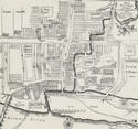
 Glasgow's mediaeval street pattern prevailed for much of this period. From the Cross, four main thoroughfares radiated: High Street towards the Cathedral, Trongate westwards, Gallowgate eastwards to the Molendinar, the Saltmarket via Bridgegate to the Clyde. Roughly made and largely unpaved, they were complemented by many narrow, twisting wynds.
 Muddy, poorly drained streets were not conducive to civic pride. In 1578, the Council brought expertise from Dundee and subsequent minutes abound with references to road maintenance, one (in December 1605) implying there existed a programme to pave all the principal streets.
 Although west of the High Street/Saltmarket axis saw some development in the 17th century, notably Candleriggs (1668), the great expansion came later, and chiefly in response to the determination of the well-to-do to escape the overcrowding around the Cross. Development began in St Andrew's Square in 1735, and further north around the future Duke Street in 1755. But expansion was marked principally by a drive westwards that saw extensions of the Broomielaw (1722) and of Trongate into Argyle Street (the old West Port being demolished in 1751). Many new streets appeared, running north/south, governed by strict regulations as to dimensions and quality. Thus were formed King Street (1722), Virginia Street (1753), Miller Street (1762), Queen and Buchanan Streets (1765), Jamaica Street and the new bridge (1760 and 1772), St Enoch Square (1768), Stockwell Street (1771) and Dunlop and Maxwell Streets (1772). Around 1770 grandiose plans were also afoot for the Ramshorn and Meadowflat lands, around today's Ingram Street.