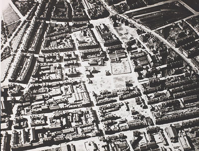
An aerial view of Calton looking west, c 1950s.
In the top left hand corner of the picture is Glasgow Green, with London Road running from top to bottom on the left. The major road on the right, also running from top to bottom, is the Gallowgate. The road across the top of the photograph connecting Gallowgate and London Road is Bain Street, and beyond it is the Barras market; at the foot is Abercromby Street.
Much of old Calton was demolished in the late 1920s and early 1930s. 1,280 houses were swept away and replaced with new tenements providing just 282 homes.
Reference: Glasgow University Archive Services, PHU64/16
University of Glasgow
Keywords:
aerial views, Barras, Glasgow Green, markets, parks, slums, tenements
You have 0 images in your photo album.