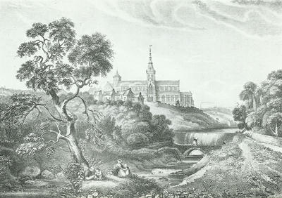
An idyllic view of Glasgow Cathedral looking north from the banks of the Molendinar Burn, drawn by William Brown in 1822. The Fir Park is on the far right.
The Drygate Brig or Bridge, is just downstream from a weir. The Molendinar was bridged at this spot in medieval times, and the bridge was also sometimes known as the East Brig. The road led west up "Hangman's Brae" to the Cathedral - the hill got its name as condemned men were taken along it on their way to the gallows, which were set up in the ruins of the old Bishop's Palace from 1784 until 1814.
The name Molendinar is probably derived from the Latin molendinarius, meaning "belonging to a mill", and it once provided the water power for both the Town's Mill and the Sub Dean's Mill. This weir was probably built in connection with the latter, which ground oats. The weir, bridge and mill were removed in the 1860s to permit the burn to be covered over and Wishart Street built on top.
Reference: GC 941.435 OLD
Reproduced with the permission of Glasgow City Council, Libraries Information and Learning
Keywords:
bridges, burns, Drygate Bridge, Drygate Brig, East Bridge, East Brig, East Port, Fir Park, Glasgow Cathedral, Hangman's Brae, mills, Molendinar Burn, Necropolis, steeples, Sub Dean's Mill, towers, weirs
You have 0 images in your photo album.