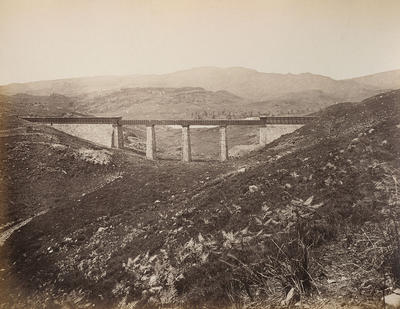
Photograph by Thomas Annan of the aqueduct bridge built to carry the pipeline from Loch Katrine across the River Duchray near Culegarton at the head of Loch Ard, 1876. In the background are the eastern slopes of Ben Lomond.
Five aqueduct bridges were built on the the route of the pipeline from Loch Katrine to Glasgow. The Culegarton bridge's ashlar piers were built 50 yards apart. The water was originally carried across them in 4-feet deep troughs, but within four years they were replaced with wrought iron pipes which are 6.5 feet wide and 8 feet high.
The aqueduct carries water across 26 miles of rough country from Loch Katrine to the Mugdock Reservoir near Milngavie, to the north-west of the city, and has a "fall" of 10 inches per mile. The water is then carried the remaining 8 miles to Glasgow in two pipes.
Turf-roofed timber huts were erected along the route during construction to house the navvies who worked on the aqueduct. Some of these navvy camps had schools, shops and churches. One, at the head of Loch Chon, was nicknamed "Sebastopol" (the location of a famous battle of the Crimean War) due to the incessant blasting operations that were required to complete a tunnel. Eighty tunnels were built along the route, excavated and blasted through soil and hard rock by an army of approximately 3,000 navvies.
Reference: D-WA 22/1/11
Reproduced with the permission of Glasgow City Council, Libraries Information and Learning
Keywords:
aqueducts, bridges, labourers, Loch Ard, Loch Katrine water scheme, navvies, navvy camps, pipelines, public water supply, River Duchray, schools
You have 1 image in your photo album.