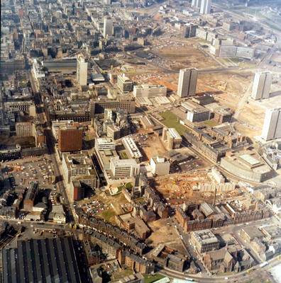
An aerial view of Townhead and the city centre, looking west from High Street, c 1970. High Street snakes along the bottom of the picture, while George Street extends westwards on the left. To the north of George Street is the expanding new University of Strathclyde, with the orange coloured Livingstone Tower standing out. Numerous gap sites indicate the scale of the redevelopment which was taking place in the Townhead area.
Townhead was declared a Comprehensive Development Area in 1962, to allow for the construction of the M8 motorway and the expansion of the University of Strathclyde. The plan proposed to reduce the number of dwellings from 6,500 to 2,400, the population from 19,000 to 7,000, and the number of shops from 420 to 60. Wholesale demolition marked the end of an era for what had been a close-knit community, with heavy industry sitting cheek by jowl alongside overcrowded tenements.
Reference: P1/9; AC249087
Reproduced with the permission of Strathclyde University Archives
Keywords:
aerial views, CDAs, Comprehensive Development Areas, demolition, Livingstone Tower, M8 motorway, motorways, tower blocks, town planning, University of Strathclyde, urban regeneration
You have 0 images in your photo album.