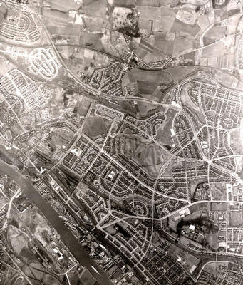
An aerial photograph of Knightswood and the surrounding areas taken by the RAF in March 1950.
A small stretch of the River Clyde from Yoker to Scotstoun is visible in the bottom left corner. In the centre of the photograph is Knightswood Golf Course with Knightswood Park above it to the north. North Knightswood became part of Glasgow in 1912 and the rest was annexed in 1926. Glasgow Corporation built what it termed "ordinary" council housing in Knightswood in the inter-war period - low-density semi-detached houses with gardens intended for the relatively affluent working class families.
The Great Western Road snakes from Drumry in the top left corner past Drumchapel, Blairdardie and Knightswood to the busy intersection at Anniesland Cross on the far right. The area around the village of Drumchapel (annexed by the city in 1938) was still largely farmland in 1950. A council housing scheme was built there in the 1950s and 1960s but unlike Knightswood consisted of tenements, terraced houses and some high-rise flats and was not provided with a wide range of amenities.
Reference: 1095
Crown copyright is reproduced with the permission of the Controller of Her Majesty's Stationery Office
Keywords:
aerial views, fields, golf courses, housing estates, housing schemes, Knightswood Golf Course, Knightswood Park, parks, RAF, River Clyde, roads, Royal Air Force, villages
You have 0 images in your photo album.