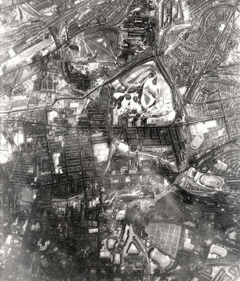
An aerial photograph of Alexandra Park and surrounding areas in the East End, taken in January 1959 by the RAF. The snow-covered open spaces of the park stand out clearly from the surrounding tenements and vast industrial production plants.
Dennistoun, laid out as a middle class suburb in the 19th century, lies to the south-west of the park and the post-1919 council housing estates of Riddrie and Carntyne to the east. Directly south of the park is Haghill, separated from Camlachie by Duke Street which runs west to east and becomes Shettleston Road near the football stadium on the right.
The Eastern Necropolis lies in the bottom right corner. To the north of it is the vast Parkhead Forge, founded in the 1830s and greatly extended by William Beardmore & Co before its demolition in the 1970s, to be replaced with the East End's largest shopping centre. To the south of the cemetery is Celtic Park, home of Glasgow Celtic FC and affectionately known as "Paradise" to its supporters.
Reference: 153
Crown copyright is reproduced with the permission of the Controller of Her Majesty's Stationery Office
Keywords:
aerial views, Alexandra Park, Celtic Park, cemeteries, Eastern Necropolis, football stadiums, housing estates, housing schemes, Paradise, Parkhead Forge, parks, RAF, roads, Royal Air Force, shopping centres, steelworks, tenements, The Forge, William Beardmore & Co
You have 0 images in your photo album.