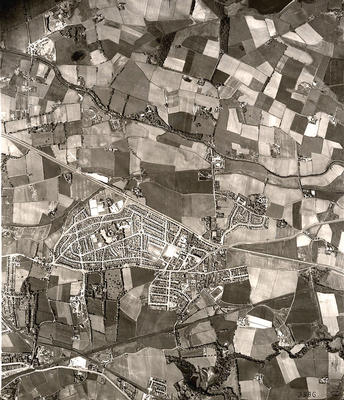
An aerial photograph of the Garrowhill and Baillieston area, surrounded by the fields and open countryside, taken in May 1950 by the RAF.
Garrowhill and Baillieston lie between the Edinburgh Road to the north and Glasgow Road to the south. The small village of Swinton is just north of the Edinburgh Road, and Mount Vernon appears in the bottom left corner of this photograph. Housing estates such as those at Barlanark and Easterhouse have yet to be built. North Calder Water meanders through the fields, bottom right, and the Monkland Canal crosses to the north.
Baillieston was originally a small mining village which grew up alongside others such as Crosshill and Barrachnie. Neighbouring Garrowhill was developed as a private housing estate during the 1930s. Baillieston was brought within Glasgow's city boundaries in 1975, under the terms of the Local Government (Scotland) Act, 1973.
Reference: 1215
Crown copyright is reproduced with the permission of the Controller of Her Majesty's Stationery Office
Keywords:
aerial views, Bishop Loch, canals, coal mining, farming, fields, housing estates, housing schemes, Local Government (Scotland) Act, 1973, lochs, M8 Motorway, mining villages, Monkland Canal, motorways, North Calder Water, RAF, Royal Air Force, suburbs
You have 1 image in your photo album.