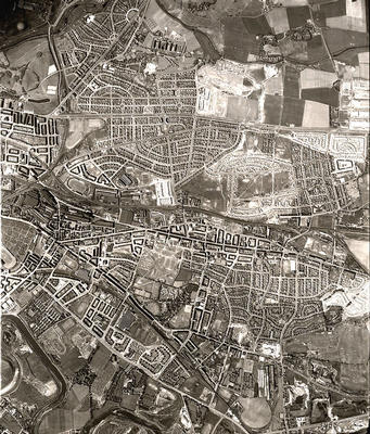
An aerial photograph of Tollcross, Shettleston and surrounding areas of the East End taken in May 1950 by the Royal Air Force.
The section of London Road from Celtic Park to Auchenshuggle runs across the bottom left hand corner of the photograph, with the River Clyde winding through fields below it. Near the centre is the large expanse of Tollcross Park, just north of Tollcross Road and south of Shettleston Road.
The prominent road running across the top of the image is the busy Edinburgh Road, with Cumbernauld Road leading off diagonally from the left. The route of the Monkland Canal is clearly visible north of the Edinburgh Road, its route subsequently followed closely by the M8 Motorway. The fields in the top right corner disappeared under the post-war housing estates built at Cranhill (where work appears to be underway in this photograph) and Ruchazie.
Reference: 1212
Crown copyright is reproduced with the permission of the Controller of Her Majesty's Stationery Office
Keywords:
aerial views, canals, Celtic Park, housing estates, housing schemes, M8 Motorway, Monkland Canal, motorways, parks, RAF, River Clyde, roads, Royal Air Force, stadia, stadiums, tenements, Tollcross Park
You have 1 image in your photo album.