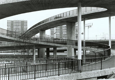
A tangle of flyovers and walkways, some of them leading nowhere, viewed looking east over the M8 from close to the junction of Argyle Street and North Street, c 1980. The Kingston Bridge is to the right. In the background is the Anderston Centre.
The creation of the Anderston Cross Comprehensive Development Area in 1961 led to the heart being ripped out of the community in Anderston. The justification was the need for an inner ring road to relieve traffic congestion and the deplorable condition of local housing, with just 9 per cent of houses considered in an acceptable sanitary condition. By 1970, the Anderston section of the ring road and the Kingston Bridge had been completed.
The Anderston Centre, completed in 1973, was a concrete complex of shops and housing with a bus station on the ground floor. The shops found trading conditions difficult, and many of them soon closed. Anderston Bus Station closed in 1993. The bleak concrete buildings and passages became targets for vandals, and the development was widely regarded as an eyesore.
Reference: Bulletin photographs, Box 6, Anderston X Development
Reproduced with the permission of Glasgow City Council, Libraries Information and Learning
Keywords:
Anderston Bus Station, Anderston Centre, Anderston Cross Comprehensive Development Area, CDAs, comprehensive development areas, concrete, flyovers, Kingston Bridge, M8, motorways, pedestrian footbridges, slum clearance, urban regeneration, walkways
You have 0 images in your photo album.