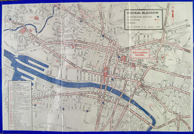
This map of central Glasgow was produced by the city's Information Bureau in 1970, to help tourists find their way around and to identify the main sights of interest.
The grid pattern of city centre streets can be seen clearly. Although not indicated on this map, however, Glasgow was in the midst of major upheaval in 1970. The construction of the M8 through the north of the city and south to the new Kingston Bridge (which opened in 1970) would completely alter the character and appearance of many neighbourhoods, particularly Cowcaddens and Anderston.
Reference: Mitchell Library, GC 912 (1970)
Reproduced with the permission of Glasgow City Council, Libraries, Information and Learning
Keywords:
docks, Information Bureau, Kingston Bridge, M8 Motorway, maps, tourism
You have 0 images in your photo album.