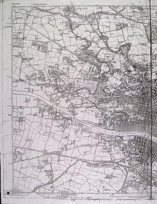
The first 6-inches to the mile Ordnance Survey map of Glasgow was published in 1865. This is the western section of that map, Lanarkshire Sheet VI.
In 1853 an Ordnance Survey office was opened in Glasgow at 205 St Vincent Street. Captain John Bayly was appointed Divisional Officer. It was Bayly who supervised the survey of Lanarkshire which was carried out in 1858. The 25-inch maps were published first, in 1860, with the 6-inch maps, based on the same survey, appearing from 1863. Glasgow's was the last one published, in 1865.
The 6-inch maps were engraved on copper plates and issued as large sheets of 36 inches by 24 inches, thereafter being produced by photographic reduction. Unlike the 25-inch maps, contour lines are shown. Only minor details are omitted from the 6-inch maps, with streets and blocks of property clearly distinguishable.
Reference: Mitchell Library, Glasgow map drawers
Reproduced with the permission of Glasgow City Council, Libraries Information and Learning
Keywords:
contours, copper plates, maps, Ordnance Survey, surveyors, surveys
You have 0 images in your photo album.