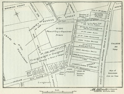
A map of the area west of High Street showing the location of the lands which had belonged to the Franciscans (centre) among other plots of land with indications of their ownership in the 18th century. The broken lines show the lay out of roads as they were in 1904 when City Engineer A B McDonald drew up this plan.
The Franciscans, or Greyfriars, came to Glasgow in the 1470s or 1480s and were gifted land by Bishop John Laing and by Thomas Forsythe, Rector of Glasgow. In 1511 Robert Blackadder gave the Greyfriars a strip of ground 20 feet wide on the west side of their grounds, in order that they could extend their monastery, house and yards.
The Franciscans' buildings are believed to have been destroyed about 1560 in the looting and rioting that followed the departure of Archbishop Beaton and the Roman Catholic hierarchy from Glasgow. Their lands were transferred to the ownership of the Town Council, and income from their rent or sale was allocated to the University.
Reference: Mitchell Library, G 941.435 REN
Reproduced with the permission of Glasgow City Council, Libraries Information and Learning
Keywords:
Archbishops, city engineers, Franciscans, Grammar School, Greyfriars, Greyfriars Parish Church, maps, Monks, plans, Reformation, riots
You have 14 images in your photo album.