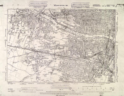
The second 6 inches to the mile Ordnance Survey map of Glasgow was published in 1896-1897, being a revision of the 1858 survey. This is the south-western section of the city, Lanarkshire Sheet VI SW. The area covered by this sheet is 6 miles east to west and four miles north to south. Contour lines are shown.
The dotted line is described as the county boundary, Glasgow having been raised to the status of County of the City of Glasgow in 1893. A large part of this section is still outside the city, as Govan remained an independent burgh until 1912. An extension of the city boundary in 1891 had brought the residential suburb of Pollokshields into the municipal area.
The dominant feature of this section is the River Clyde, with the docks of Glasgow Harbour, and railway lines leading to them, taking centre stage. Shipyards have appeared downstream from the docks. Areas such as Mosspark and Dumbeck are still rural in character.
Reference: Mitchell Library, Glasgow map drawers
Reproduced with the permission of Glasgow City Council, Libraries Information and Learning
Keywords:
city boundary, contours, docks, Glasgow Harbour, Ibrox Park, maps, Ordnance Survey, railways, River Clyde, shipyards
You have 1 image in your photo album.