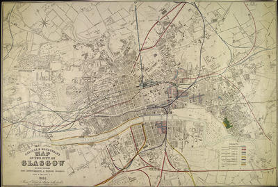
Cartographer Hugh H Maclure gave special emphasis to railways for "Maclure & Macdonald's map of the City of Glasgow" published in 1866, with the use of colour coding for the various railway companies. Authorised and proposed railways are shown along with existing lines.
The first Ordnance Survey maps of the city were available at this time and may have provided the basis for Maclure's map. It indicates proposed city improvements, with areas where houses were to be demolished shown in pink, and proposed new streets in blue. The slum clearance programme had already started in 1866.
The River Clyde is shown in some detail, with bridges and the weir marked. Shipyards and both existing and proposed docks are shown, along with the Glasgow Harbour Tramways, on both banks of the river.
Reference: Mitchell Library, Glasgow map drawers
Reproduced with the permission of Glasgow City Council, Libraries Information and Learning
Keywords:
bridges, docks, Glasgow Harbour Tramways, Maclure & Macdonald, maps, Ordnance Survey, railways, River Clyde, shipyards, slum clearance, slums, weirs
You have 1 image in your photo album.