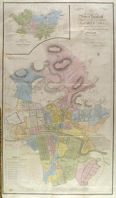
James Cleland's "Map of the ten parishes within the Royalty and the parishes of Gorbals & Barony of Glasgow" was produced in 1831 to accompany his Enumeration of the inhabitants of the City of Glasgow and County of Lanark, prepared for the national census of that year. The insert for Barony and the Royalty is on a smaller scale than the main map.
The map extends further from the city centre than most maps of the time, especially to the north. Hill shading is shown on the outskirts, but not in the city. A significant addition is the newly opened Glasgow & Garnkirk Railway. The map is dedicated to Lord Provost Robert Dalglish.
Reference: Mitchell Library, GC f314 (1831)
Reproduced with the permission of Glasgow City Council, Libraries Information and Learning
Keywords:
censuses, Garnkirk & Glasgow Railway, Glasgow, Garnkirk & Coatbridge Railway, maps, parishes, railways
You have 1 image in your photo album.