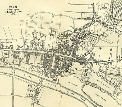
1783 was the year of publication of Glasgow's first directory, John Tait's Directory. The engraver of this map, produced in the same year, was James Lumsden. His name is recorded in the directory.
Only the city's main streets are named in Lumsden's map. Glasgow Cathedral is depicted in a drawing. The future development in the Ramshorn area is shown in outline, but the St Andrew's Square development is not. The little village of Grahamston, once famous for its breweries and much of which now lies beneath Central Station, is on the far left of the map.
Reference: Mitchell Library, GC 941.435 MCG
Reproduced with the permission of Glasgow City Council, Libraries Information and Learning
Keywords:
directories, engravers, Glasgow Cathedral, maps
You have 1 image in your photo album.