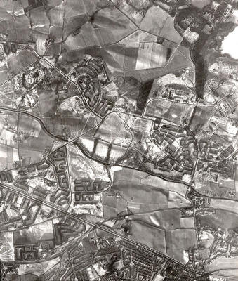
An aerial photograph of the Easterhouse area taken in January 1959 by the RAF.
Bishop Loch is visible in the top right corner, with Gartloch Hospital to the left of it. Below the loch lies Easterhouse, originally a village but developed as a major housing estate by Glasgow Corporation during the 1950s. Open fields separate Easterhouse from Provanhall to the west. A section of the Monkland Canal runs from east to west below Easterhouse, along the route now followed by the M8 Motorway.
Cutting across the bottom left hand corner of the photograph is the Edinburgh Road, separating Wellhouse from Barlanark to the south and then continuing east past Baillieston. The fields lying between Easterhouse and Baillieston, west of Swinton, were subsequently filled with houses.
Reference: 189
Crown copyright is reproduced with the permission of the Controller of Her Majesty's Stationery Office
Keywords:
aerial views, Bishop Loch, canals, fields, Gartloch Hospital, hospitals, housing estates, housing schemes, lochs, Monkland Canal, RAF, roads, Royal Air Force
You have 0 images in your photo album.